• Start-up
  • Planning
  • Action
  • Evaluation

Restoration of a former landfill to restore ecosystem function, and prairie and riparian ecosystems. The Save Maumee organization is aims to intentionally prepare the site to cope with climate change impacts by placing tree species along riparian zones and lowland ponds to maximize floodwater storage, to prepare for periods of drought, and to increase plant species diversity.

Overall, the site managers plan to increase tree diversity of native trees acclimated for riparian areas, while improving habitat and restoring maximum connectivity to surrounding natural areas in the watershed/floodway ecosystem. The goal is to take actions that can improve water quality leveraging the natural capacity of ecosystems to increase stormwater detention.

Project Area

landfill
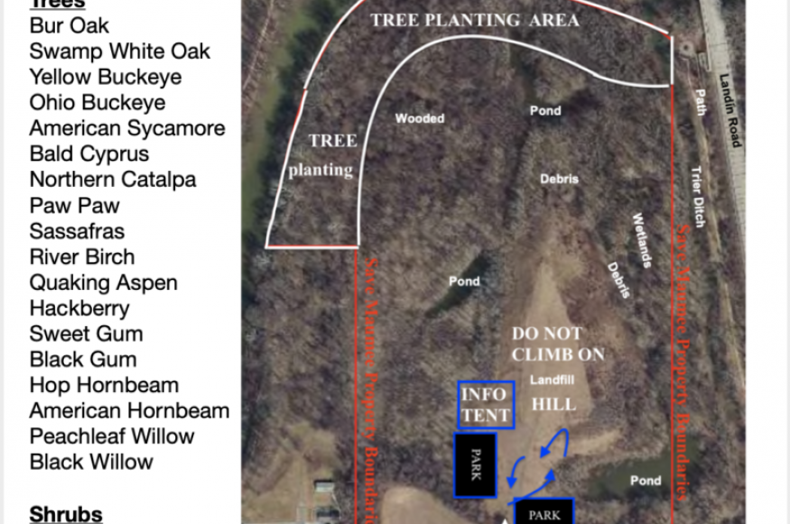
The project area contains 56.4 +acres located on the Maumee River, just east (and downstream) of Fort Wayne, in New Haven, Indiana. Partly a capped landfill (11 of the 56.4 acres), the site’s groundwater is tied to the water table. To the east of the property, flows a major tributary called Trier Ditch and drains 18,039.4 acres alone. A forested area with several wetlands covering 1,700+ linear feet of riparian area on the Maumee and 1,500 linear along the Trier Ditch. The site includes two HUC12 watersheds, with 3 ponds and an 8.15+ acre wetland located on the property.

Management Goals

Overall, the site managers plan to increase tree diversity of native trees acclimated for riparian areas, while improving habitat and restoring maximum connectivity to surrounding natural areas in the watershed/floodway ecosystem. The goal is to take actions that can improve water quality leveraging the natural capacity of ecosystems to increase stormwater detention.

Key components of the Forested Watershed Landfill restoration project:

Water -  Maintain 3 ponds (one is very big and variable) from becoming stagnant and increase diversity of aquatic life in them. Increase stream connectivity of Trier Ditch (navigable waterway) to the Maumee River.

Wetland - Selectively remove Invasive species. Increase tree diversity and age progression of trees through proper selection based on specific tree’s soil and water needs. Maintain 3 ponds (one is very big and variable) from becoming stagnant and increase diversity of aquatic life in them. Increase stream connectivity of Trier Ditch (navigable waterway) to the Maumee River.

Riparian - Selectively remove Invasive species. Increase tree diversity and age progression of trees through proper selection based on specific tree’s soil and water needs. Increase stream connectivity of Trier Ditch (navigable waterway) to the Maumee River.

Landfill - Selectively remove invasive species. Find legal ways to create a prairie without disturbing the cap of the landfill. 

Climate Change Impacts

Project area is moderately vulnerable to climate change. Broad scale impacts that are most relevant are flashiness, loss of diversity and adaptability, more water retention due to increased precipitation and more water flowing into the floodway areas of the site, stagnant water, higher temperatures may harm low adaptability species from disturbances of lands. We are anticipating amplification of existing stressors for arboreal and northern tree species with less tree regeneration, recruitment and productivity as surface water temperatures and heat index rise. For this project, the most important anticipated climate change impacts include:
Temperatures in the Midwest are projected to increase by 4.5 to 9.5 degrees Fahrenheit by 2085
Average annual precipitation is projected to increase slightly in northern portion of the Midwest, but may decrease in the southern half of the region. This could exacerbate current issues with stormwater generated of impervious surfaces upstream
High streamflow events are already becoming more frequent and are delivering increased water volumes that may affect forest composition as “violent” flashy conditions occur
The annual freeze-free season is expected to increase by 18 to 26 days in the Midwest by 2055
Forested wetland and lowland is regionally unique, decently diverse, and has low adaption probability to local hydrologic regimes; and therefore sensitive to climate changes that may modify wetland hyrdoperiod
Anticipating increases in invasive species due to climate change and gaps due to native fatalities caused by climate change. Potential impacts that can influence invasive species growth: fewer freezing days, longer growing season length
Low diversity ecological systems are at greater risk from climate change
Seasonal variation in soil moisture and altered precipitation may influence the magnitude and duration of flood events
Soil needs to be captured and deposited onsite or on the land, instead of continuing to erode and cause sedimentation in surrounding streams. Upstream conditions are variable/dynamic
Retaining a forest of native adaptable species needs human-aid to increase healthy diversity for flora and fauna

Challenges and Opportunities

Climate change will present challenges and opportunities for accomplishing the management objectives of this project, including:

Challenges

Increased flashing and stagnant flooding. Flooding and flashiness of site due to increased rainfall in one setting could erode project before it is complete
Increased rainfall may alter stream connectivity in new and unpredictable ways, moving flood water into a different direction than expected
Constructed ponds need a steady hydrology to maintain water quality and habitat. Altered hydrologic regimes may overwhelm the system after flooding events, and increase water quality issues if water becomes stagnated during drier periods
Cannot accurately predict future extent of water levels in order to build into designs
Loss of species due to more rapid changes in temperature effecting near term restoration on site, affecting new plantings. Long term changes to heat zones may affect native plants along edges, and reduce habitat for some.
More intense temperatures. In the near term, species planted may not thrive and may die due to extreme conditions
The hill may experience drying out after several years. The plastic coating under the surface may crack and break-down or begin to pool if standing water sits on the top
Shade is critical to offset rising temperatures in the ponds, yet trees present in this area may be negatively affected by climate change
Warming of shallow ponds may reduce habitat and aquatic species life cycles for frogs, turtles and other aquatic animal species
Maintaining long-term funding to manage the site, and volunteer support to implement actions

Opportunities

Can create a stable habitat for wildlife by incorporating climate change and native planting considerations into restoration plan. Introducing adaptive species located in more southerly habitats into locations now may help the landscape cope with changes
Routine higher water levels and flooding can be beneficial to pond water quality
Designing the system to cope with flashy flood events in restoration plans may reduce negative effects of future flashy flows downstream
Increased growing season length may increase natural water filtration by native plants that can reduce stormwater impacts on the landscape
Improving flow and connectivity of the ditch could help reduce flooding and help species reach the Maumee River
More community around the topic of water quality and adaptation to climate change. Site can demonstrate the value of forests as a flood mitigation strategy and will make strong connections between ecology and climate change

Adaptation Actions

Project participants used the Adaptation Workbook to develop several adaptation actions for this project, including:

Area/Topic
Approach
Tactics
Water, wetland
Choose native aquatic plant species to plant them in and around ponds. Seek advice from local native plant experts to narrow list of species for site based on soil and moisture needs.
Water, wetland, landfill (whole property)
Map project site (53 acres), use map to identify most suitable locations for tree plantings. This process will seek input from Maumee River Basin, IDEM, Woody Ware House, Purdue Extension Office, USDA Forest Service, and others.
Plant Bur Oak, Swamp white oak, Yellow Buckeye, Ohio Buckeye, American Sycamore, Bald Cyprus, Northern Catalpa, Paw Paw, Sassafras, River Birch, Quaking aspen, Hackberry, Sweet Gum, Black Gum, Hop Hornbeam, American Hornbeam, Peachleaf Willow, Black Willo
Plant shrubs: Pussy willow, Sandbar willow, Silky dogwood, Spicebush, Elderberry, Nannyberry, Serviceberry, Common ninebark
Wetland, riparian, landfill
Selectively remove invasive species around the wetland area (8.15 acres). Partner with organizations to help complete this task.
Wetland, riparian
Work with local tree supplier, and the Purdue Extension to help choose tree species that may survive and thrive in frequently inundated and flashy flood flow areas.
Riparian, Wetland, Water
Design Trier Ditch to maximize flood flows and increase connectivity with help of Maumee River Basin.

Monitoring

Project participants identified several monitoring items that could help inform future management, including:
Survival Rate of Trees Planted (planted 550 Trees), at 70% after 3 years.
Locate each tree and record survival every year for 4 years

Learn More

Keywords

Flooding
Invasive species
Soil
Water resources
Wetlands

Last Updated