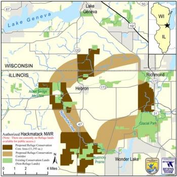
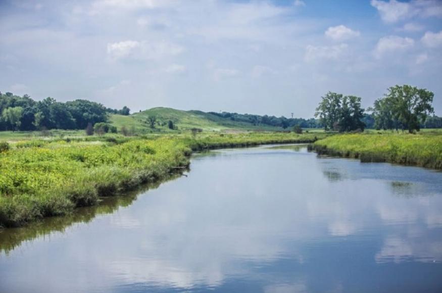
Project Area
 Located in McHenry County, Illinois and Walworth County, Wisconsin — just an hour’s drive for the 12 million residents of the metropolitan areas of Chicago, Madison, Milwaukee, and Rockford — Hackmatack National Wildlife Refuge was established in 2012. It was created as the first federal wildlife refuge within 100 miles of Chicago and affords permanent conservation protections to the landscapes Openlands and its partners are working to restore.
The refuge’s name, Hackmatack (hack-ma-tack), is an Algonquin word for the very old tamarack trees found in the refuge area that are living remnants of the last Ice Age. As lands for Hackmatack are protected, the refuge will eventually encompass 11,200 acres of this glacial landscape. Over time, Hackmatack will become a mosaic of protected lands that provide habitat for grassland birds, recreation and education opportunities for people, and economic support for local communities.Ultimately, Hackmatack NWR will encompass over 10,000 acres mostly in McHenry County, IL. It has many waterways (and varying landowners and managers), which form the focal point of our adaptation recommendations. It is also home to agriculture tracts and numerous old oak trees.
Management Goals
The overall goal of the project is to manage canopy cover to improve the headwaters and streams in the Nippersink Watershed. Specific objectives include:
Agricultural areas:
- Determine the shade potential of trees or shrubs. (1 year)
- Make future recommendations of management and acquisition for sites in the Hackmatack National Wildlife Refuge.
Wetlands and water bodies:
- Explore differences in stream temperature and quality due to different vegetation treatments. (2-3 years)
Climate Change Impacts
For this project, the most important anticipated climate change impacts include:
Increased frequency and intensity of flooding could affect existing canopy and threaten the survivability of new plantings.
Increased droughts could also negatively impact existing trees, in particular numerous stands of old oaks.
Droughts and seasonal precipitation issues conflicting with with agricultural production could also diminish the agricultural output of the region.
Challenges and Opportunities
Climate change will present challenges and opportunities for accomplishing the management objectives of this project, including:
Challenges
The dual threat of increased drought and flood can potentially make specific recommendations difficult given the many waterways in the region.
New plantings of trees could be lost to flooding incidents along waterways.
Several prevalent species in the Hackmatack area are considered highly vulnerable to climate change, namely white pine, grey and paper birch, and black cherry.
Flooding could drastically affect canopy cover along waterways in the Hackmatack region; further, drawing conclusions about water temperature differences could be difficult with an increase in the number of flooding events.
Opportunities
If certain species show an ability to survive droughts in the area, then these can be recommended to help maintain or increase canopy cover.
New species that are recommended for planting with low vulnerability to climate change can be used to replace invasive, shade tolerant species such as European buckthorn.
Adaptation Actions
Project participants used the Adaptation Workbook to develop several adaptation actions for this project, including:
Area/Topic
Approach
Tactics
Agricultural areas
2.2. Prevent the introduction and establishment of invasive plant species and remove existing invasive species.
5.2. Maintain and restore diversity of native species.
7.2. Maintain and create habitat corridors through reforestation or restoration.
5.2. Maintain and restore diversity of native species.
7.2. Maintain and create habitat corridors through reforestation or restoration.
remove invasive species, in the immediate to short term, and replace with recommended low-vulnerability, shade-tolerant species to protect waterways.
Increase species diversity in the Hackmatack region in the short, medium, and long term.
Wetlands/Water bodies
1.3. Maintain or restore riparian areas.
6.1. Manage habitats over a range of sites and conditions.
6.2. Expand the boundaries of reserves to increase diversity.
6.1. Manage habitats over a range of sites and conditions.
6.2. Expand the boundaries of reserves to increase diversity.
Protect waterways by maintaining or increasing tree canopy
Monitoring
Project participants identified several monitoring items that could help inform future management, including:
Percent tree canopy along riparian corridors, and in the Hackmatack region as a whole.
Number of different species, in particular native and/or climate-change tolerant tree species.
Percent of newly planted trees that survive.
Keywords
Agriculture/ Agroforestry
Grasslands
Landscape-scale planning
Oak
Restoration
Water resources
Wetlands
Wildlife habitat

